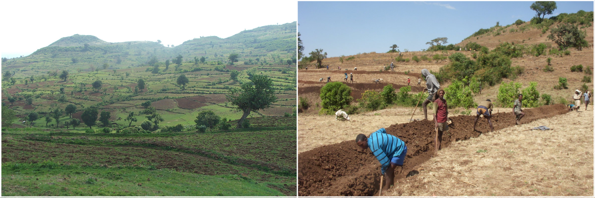
The Aba Gerima watershed covers the upper portion of Lake Tana sub-basin in north-western Ethiopia. Agriculture is its mainstay, with cereal cultivation occupying about 60% of 984 hectares. But the ecology of the landscape is threatened by the conversion of natural vegetated land to cropland, and continuing land degradation has been affecting the livelihoods of farmers.
From 2012 onwards, a program of voluntary community labor investment based Natural Resource Management (NRM) has been applied to Aba Gerima, including the building of farm bunds, vegetative hedgerows, run-off waterways on cultivated lands, check dams on gullies, exclosures to restrict grazing and in-situ moisture harvesting structures to rehabilitate the degraded hills. In addition, agricultural practices such as improved crop varieties, fodder species, livestock breeds, agricultural machinery and intensified home garden activities have been demonstrated and promoted.
Community-powered resource management
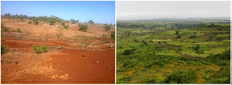
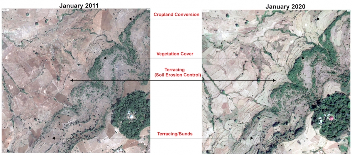
The results have been remarkable: soil conservation bunds built at strategic locations reduced soil erosion by 60-85%, resulting in a 30-40% increase in crop yield due to sediment retention, according to field monitoring and geospatial data. Vegetation cover increased by 50-150%, with an increase in the reclamation of degraded grazing lands and a decrease in the rate of conversion of natural vegetated lands to cropland.
Community participation was key to the greening of the Aba Gerima watershed. "Farmers contributed voluntary labor for the construction of terraces. Each farmer constructed 4-6 meters of soil bund per day following a community mobilization campaign in January 2012. In just a year's time the impact of these interventions could be seen," says Dr. Gete Zeleke, Director of the Water and Land Resource Centre (WLRC) in Ethiopia.

The deep engagement of the farmers living in the watershed drew on a traditional basis for regulation. “Community bylaws played a strong role in the building and management of NRM structures and also in restricting free grazing,” explains Dr. Gizaw Desta, Research Management Coordinator in Watershed Management at the International Crops Research Institute for the Semi-Arid Tropics (ICRISAT). “This reversed the soil degradation caused by human activity and overgrazing.”

Dramatic, rapid impact
The impact of the interventions in Aba Gerima as well as neighboring watersheds where NRM was not applied was assessed through temporal satellite data and in-situ monitoring from 2013 to 2019. According to Dr. Murali Krishna Gumma, Head of the Remote Sensing/Geographic Information System Unit at ICRISAT, the following impacts were clearly attributable to the NRM approach:
- Increase in vegetation cover: There was a substantial change from degraded/bare land to vegetation, and a decrease in the rate of conversion of vegetative land cover to cropland in Aba Gerima. In contrast, in the neighboring watersheds, the trend of land-use change from perennial vegetation to cropland continued.
- Reduced soil erosion: With the construction of a total of 127 km of bunds, about 8,973 tons of sediment were retained that otherwise would have been washed into the rivers and out of the watershed. This is equivalent to a 9.9 t ha-1 rate of soil erosion in the watershed, significantly lower than current average soil erosion (25-65 t ha-1) in Lake Tana sub-basin. Sediment retention on conservation bunds led to a 30-40% increase in crop yield.
- More fodder crops: NRM structures were used to grow vegetative fodder species such as river hemp, pigeon pea and Napier grass. Hedgerows on one hectare of soil conservation bunds can easily accommodate 2,100-2,800 kg of fodder shrubs, which can feed a cow throughout the year with supplemental grazing.
- Reclaiming degraded wastelands: Abandoned grazing hillslopes with severe soil degradation and bare vegetation were terraced and rehabilitated for fodder use and natural regeneration, increasing cover by 50-150%.

Aba Gerima demonstrates what NRM practices can achieve over time with the right approach. "ICRISAT has led efforts in such participatory integrated watershed development for almost two decades," says Dr. Anthony Whitbread, Research Program Director at Innovation Systems for the Drylands. "Building on the scaling model from India, these demonstration watersheds become 'learning sites' such as those set up in Ethiopia, Mali and Tanzania, where the donor community and policy makers may be convinced to support such initiatives." From space and at grassroots level, the inspiring results of such collaboration are plain to see.
The blog covers work undertaken by the Water and Land Resource Center project which was funded by the Swiss Agency for Development and Cooperation (SDC). The remote sensing and field monitoring data generated by ICRISAT used for this impact study was supported by the CGIAR Research Program on Water, Land and Ecosystems (WLE).
---
Thrive blog is a space for independent thought and aims to stimulate discussion among sustainable agriculture researchers and the public. Blogs are facilitated by the CGIAR Research Program on Water, Land and Ecosystems (WLE) but reflect the opinions and information of the authors only and not necessarily those of WLE and its donors or partners.
WLE and partners are supported by CGIAR Trust Fund Contributors, including: ACIAR, DGIS, FCDO, SDC, Sida and others.


