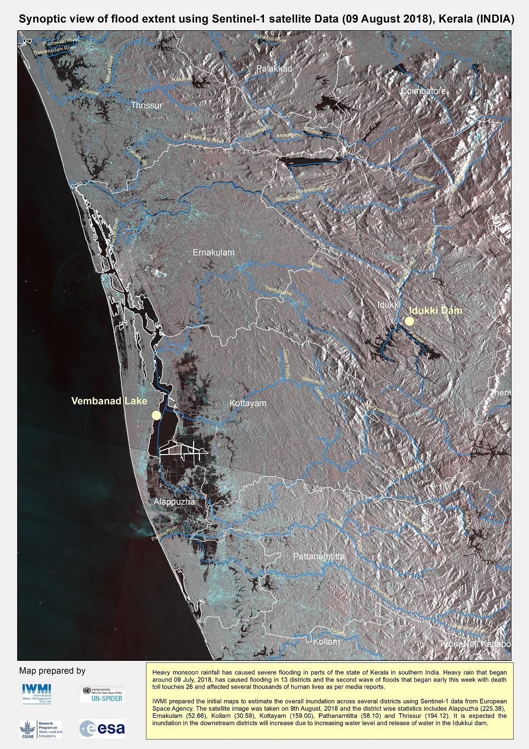
As severe floods hit India’s Kerala state, satellite maps are supporting the state government’s response. Created by the International Water Management Institute and the CGIAR Research Program on Water, Land and Ecosystems, the maps estimate water inundation, allowing decision makers to better coordinate relief efforts.
Monsoon rainfall has caused severe flooding in parts of the state of Kerala in southern India. Heavy rain that began around 09 July, 2018, has caused flooding in 13 districts, with a second wave worsening the situation in early August. The death toll is at least 26 and floods are affecting several thousands of residents, farmers and businesses, according to media reports.
Maps are being shared to Kerala State Disaster Management Authority (KSDMA) of the National Disaster Management Authority in Delhi to support their relief and rescue operations. In addition to the maps, researchers can provide an analysis on the extent of crop damage and population exposure to flood rains, information that can be used for flood impact assessment. IWMI has been regularly updating the information on Facebook using the popular Kerala Floods News page to brief people on the current situation.
IWMI/WLE prepared the initial maps to estimate the overall inundation across several districts using satellite data from the European Space Agency’s Sentinel-1. The satellite image here was taken on 9th August, 2018 with statistics indicating heavy inundation in the areas of Alappuzha (225.38 cm), Ernakulam (52.66 c), Kollam (30.59 cm), Kottayam (159.00 cm), Pathanamtitta (58.10 cm) and Thrissur (194.12 cm). It is expected the inundation in the downstream districts will increase due to increasing water levels and the release of water in the nearby Idukkui dam.
“These methods are really beginning to prove vital for India and elsewhere – especially as the world copes with such unpredictable weather,” says IWMI Senior Researcher Giriraj Amarnath.
IWMI and WLE – along with the CGIAR Resarch Program on Climate Change, Agriculture and Food Security (CCAFS) – support various research programs focusing on using satellite data to better assess floods and drought damage, help smallholder farmers get more reliable crop insurance, and measure soil moisture to help decision-makers plan for weather events that could seriously impact crops, livestock and human safety.
IWMI and WLE also recently supported the government of the Lao PDR in its efforts to assess and respond to flood damage.
Learn more by visiting IWMI's Water Risks, Climate Change and Resilience Facebook page.
Related contents

Blog Post 

Blog Post 


Related publications
How can economic incentives designed for environmental conservation support a transition to sustainable and equitable agriculture?
Moros, L.; Puerto, S.; Monroy, D.; Achaval-Torre, J.; Rueda, X. 2022. How can economic incentives designed for environmental conservation support a transition to sustainable and equitable agriculture? Colombo, Sri Lanka: Commission on Sustainable Agriculture Intensification. 42p.Integrated rice and fish systems
Dubois, M.; Akester, M.; Ou, P.; Freed, S.; Leemans, K.; Mam, K.; de Silva, Sanjiv; Smith, B.; Teoh, S.J.; Aung, H.M.; Beveridge, M.C.M.; Marwaha, N.; Phillips, M. 2021. Integrated rice and fish systems. Penang, Malaysia: CGIAR Research Program on Fish Agri-Food Systems.Program Brief: FISH-2021-14
Unlocking the potential of flood farming to reduce flood risks and boost dryland production in Ethiopia
Desta, Gizaw; Legesse, Gizachew; Amede, Tilahun; van F.Rooyen, Andre; Whitbread, Anthony. 2021. Unlocking the potential of flood farming to reduce flood risks and boost dryland production in Ethiopia. Colombo, Sri Lanka: CGIAR Research Program on Water, Land and Ecosystems (WLE). 10p.
Climate migration and social transformation: The case of West Africa
CGIAR Research Program on Water, Land and Ecosystems (WLE). 2021. Climate migration and social transformation: The case of West Africa. Colombo, Sri Lanka: CGIAR Research Program on Water, Land and Ecosystems (WLE). 4p. [WLE BRIEFING SERIES NO. 33]
Virtual regional dialogue on options to promote more inclusive weather index insurance
D.Surie, Mandakini; Aheeyar, Mohamed; de Silva, Sanjiv; Raut, Manita. 2021. Virtual regional dialogue on options to promote more inclusive weather index insurance. Workshop summary report[27-28 October 2021]. 35p.